
With over 69 million kilometres of navigable roads in 200 countries to cover, the team that monitors, builds and maintains TomTom’s digital maps are a busy bunch. The location technology specialist uses a range of sources to create its maps, implementing a fusion process to use the most relevant and accurate information from its sources.
We talked to Andy Marchant, TomTom’s Head of Visualisation Lab, about how maps may help society adjust to transportation’s ‘new normal’.
He tells us: “There are many map features; some are common ones – geometry, street names, speed limits, etc., but there are also less commonly known features like road type, index area, direction of traffic flow, turn restrictions and more, all essential to location-based applications. If there is a change in the map, each of the related features needs to be updated to ensure high quality. With many changes happening day in day out, the challenge is making sure that we can integrate these changes into the map in the shortest time possible.”
Creating high-definition maps in a manual way is just not sustainable. Due to the volume of map changes that TomTom processes (up to 2 billion per month) it has to use the latest technology to support automation.
“We’ve built AI tools that can detect features; for example, sign reflectivity to detect and correctly classify traffic signs. Similarly, TomTom currently has teams that are engaged in data labelling of many features such as for road and lane markings as well as roadside furniture, to create an evidence database so that additional AI tools can be built to further automate the creation of our HD map. By deploying AI to as many aspects of mapmaking as possible, TomTom has become smarter, more efficient and agile,” says Marchant.
Harnessing Big Data
TomTom’s maps are used by a wide range of mobility users to save fuel and cut harmful emissions. Marchant says a good example of fuel saving is within the fleet and logistics sector.
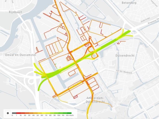
“Here our ADAS (Advanced Driver Assistance Systems) map provides information such as curvature and gradient (amongst other features). This is invaluable for trucks to move efficiently. Knowing the incline of the road and where the crest of the hill is, allows the driver to ensure the truck is in the correct gear to best maintain speed. Equally knowing the curvature of an upcoming bend allows the truck to approach the bend at the most relevant speed and maintain the correct speed to ensure efficient driving.
“This information allows the truck to maintain more average speeds across a journey and therefore be more fuel efficient. In terms of cutting emissions, our maps contain more than 300,000 EV charging points across 53 countries, we also provide routing for electric vehicles based on their power output and range to help reduce the so called range anxiety,” he adds.
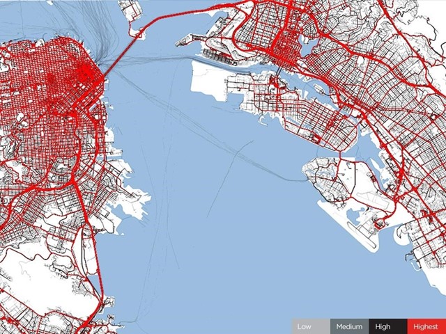
TomTom has been collecting traffic data for more than a decade. It now gathers and utilises big data in 416 cities across 57 countries and 6 continents to produce the annual TomTom Traffic Index.
We can use this information to look at the expected traffic at certain times of the day and compare this to what we see in reality. During the Covid-19 pandemic, many countries introduced restriction or guidance on movement in order to help contain the spread of the virus. It was evident very quickly which cities had been impacted the most. We saw traffic in cities like Milan drop by 85% as people stayed at home and away from the roads.
“Now, as people return to work and some kind of normality, our analytical traffic data can plot the origin and destination of journeys, helping businesses and cities plan staggered work times or implement new measures to ensure people can maintain social distancing as much as possible,” says Marchant.
Marchant says that location data will continue to be more and more important to businesses in the future and it should be used as part of their decision-making process.
“Look at how society will have to adjust to the ‘new normal’ after Covid-19. Knowing where your employees travel from and how they get to work can inform companies’ working hours or working from home policies. Cities will need to look at how to manage mobility to ensure whatever social distancing rules there are can be maintained.
"Digital mapmaking is the key to such initiatives and to ensure that it keeps pace with reality; then automation, AI and community feedback are some of the most important developments.”
Looking further ahead, if and when driverless vehicles become commonplace, maps will still retain their importance for getting from A to B.
“Autonomous or automated vehicles will always need a map, especially for things like path planning and localisation to ensure the car can maintain its autonomous state safely in complicated situations like multi-lane roads. What a map also provides is what the vehicles sensors cannot see, what’s around the next bend or over the hill.
“Also consider the limitation of cars’ sensors in poor conditions or low visibility. Can an automated vehicle perform safely in fog or snowy conditions? What about in heavy rain or where road markings are faded or missing? Maps provide context and can be relied upon even when sensors cannot perform optimally,” concludes Marchant.